The Role of Drones in Surveying and Mapping
In a short time, drones have gone from a hobbyist's novelty to a critical tool used daily across various industries. The Surveying and Mapping industry is no exception. Drones are rapidly transforming data collection, project management, and high-quality, impactful deliverables. Drones are vital to increasing the speed, accuracy, and safety of Surveying and Mapping workflows.
How Are Drones Used in Surveying and Mapping?
Aerial surveying is not a new concept. In World War II, photogrammetry was a widely used method of reconnaissance and planning. However, aerial surveying, until the last few years, required crewed aircraft and extremely expensive equipment. Therefore, it was impractical for all but the largest projects. Drones dramatically reduce equipment and training costs and increase mapping projects' safety and productivity.
The process for drone surveying is pretty straightforward. A fixed-wing or multirotor drone is equipped with a payload of sensors, including GNSS, Inertial Measurement Units (IMUs), cameras, and/or LiDAR. Data is then collected and processed to extract and create 2D or 3D data products and deliverables in a fraction of the time of conventional survey methods.
Topographic surveys may be the most effective use of drone technology for a Surveyor. Most topo surveys' size and accuracy requirements are directly in the sweet spot of a drone's capabilities. There is simply no more efficient method to capture survey-accurate topo data than by drone. Recent advances in LiDAR have brought the ability to capture ground surface not just in open areas but in tall vegetation and canopied areas to practically any size firm. For example, a LiDAR-equipped, multirotor drone can capture 100 acres in less than 15 minutes.
In addition to pre-construction site planning, Surveyors and civil engineers use drone-derived data for a variety of other applications such as urban planning and road construction:
- Urban planning: Using drones, developers can collect invaluable data and gain insights into the conditions of structures, traffic patterns, road construction, and other components.
- Forestry: Due to the sheer size of forests and other natural landscapes, drones are vital in mapping these areas and determining metrics, including forest density, merchantable tree count, species classification, tree height, and the presence of rivers or waterfalls.
- Dam surveying: Dams are essential water supplies, so advancements in dam surveying are vital. Dam surveyors use drones to measure water flow and depth, assess temperature, and detect damage.
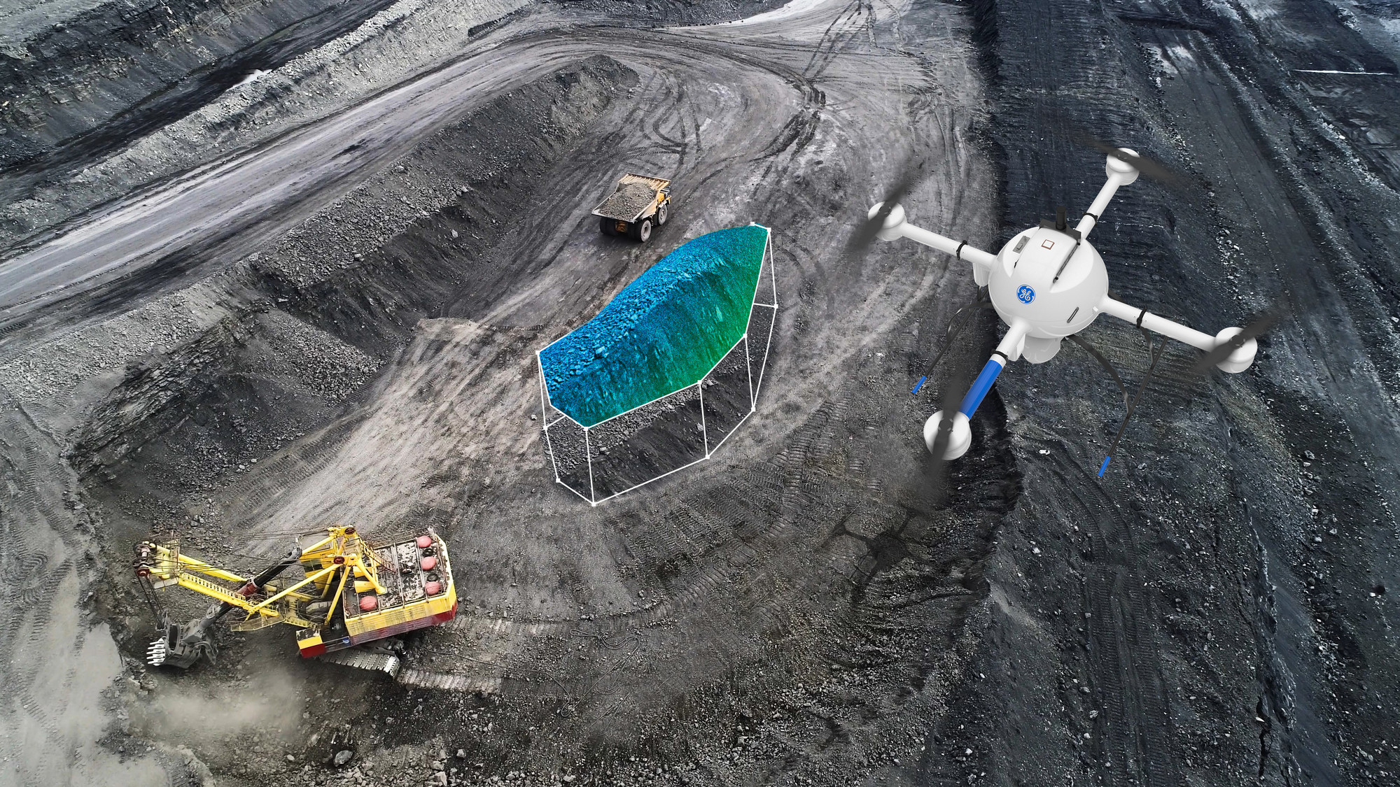
- Mining site mapping: Mine managers can use drones to determine site conditions, visualize routes for hauling logistics, measure blast efficiency, and track excavations — all of which make mining projects easier to oversee, safer to plan, and more efficient in the long run.
- Utility Inspection: While it's true that most drone inspections are visual inspections, drones can also be equipped with special sensors, such as Methane Gas detectors, which allow them to perform other kinds of inspections. Drones play a vital role in providing highly accurate data while keeping inspectors safe from chemicals, temperature issues, and any other hazards that might be in a location.
How to Complete a Drone Survey
The methods for conducting drone surveys are project-specific. These are general steps to give you a better idea of how drone surveys work:
- Regulations: Consult local guidelines for flying drones in the area you need to survey and comply with regulations, including drone classification regulations (Blue sUAS and NDAA compliance).
- Conditions: Check the weather - clear weather is ideal. Avoid flying on days with fog, rain, snow, or high winds.
- Checkpoints: Set up ground control points and checkpoints according to your project. You can place these targets strategically throughout the area you want to survey.
- Checks: Next, set up your drone by checking all parameters and cleaning the sensors. Be sure to remove your camera lens cap!
- Settings: Follow the manufacturer's guidelines for mission settings. Factors that can affect the performance of a drone mission are altitude, side and front overlap, speed, and sensor-specific settings such as the number of returns for LIDAR and image settings for photogrammetry.
- Flight and data collection: Make sure there are no obstacles, like large groups of birds or powerlines, before the drone takes off. After all checks, the drone is ready for flight.
- Post-analysis: After data collection, photogrammetry or LiDAR processing is done from the comfort of the office. Then feature extraction, data analysis, and deliverable creation are completed with minimal field time.
When it comes to settings, note that photogrammetric drones take multiple images from various positions to create comprehensive overviews. Image overlap shows how much each image is duplicated in the next one. If the overlap is too low, you won't get enough details, but if the overlap is too high, it increases the time on the field, produces large files and long processing times, and potentially creates more errors.
Benefits of Drones for Surveying
Drone technology provides many advantages in surveying and mapping, including:
- Cost-effectiveness: Surveying drones, including LiDAR-equipped systems, are no longer necessarily six-figure purchasing decisions. Photogrammetry systems start at a few thousand dollars, and LiDAR drones start in the same price range as an RTK system or Robotic total station.
- Time-saving and fewer resources: Traditional survey methods can be resource- and time-intensive. Employing drones in surveying eliminates the need for expensive or hard-to-obtain resources, speeding up projects and maintaining accuracy.
- Accuracy: Specialized drones provide high data accuracy thanks to a combination of high-resolution cameras, cutting-edge LiDAR technology, and advanced processing software.
- Accessibility and safety: Drones allow surveyors to map inaccessible areas and hazardous terrain that would be unsafe to traverse.
What to Look for in Drones for Surveying and Mapping
The most important components to consider when searching for quality drones for surveying include the following:
- Style and size: Examine if your project requires a fixed-wing or multirotor drone.
- Payload quality: Get the highest quality camera and/or LiDAR that meets your project's requirements, taking ground sample distance and resolution into consideration.
- Regulation: Double check to see if your project requires a Blue sUAS or NDAA-compliant drone (mostly used for government projects).
- Battery life: Multirotor drones have a typical battery life of 30 to 45 minutes of flight. Fixed-wing drones can fly for an hour or more. When deciding between multirotor and fixed-wing solutions, consider the typical project size.
- Specialized features: Many surveying projects require features like high-resolution LiDAR for accurate distance measurements.
Buy or Rent Drones for Your Geospatial Needs From Duncan-Parnell
Are you ready to optimize your survey and mapping projects with premium equipment, accessories, and software for mapping and GPS? At Duncan-Parnell, we partner with highly-regarded drones/unmanned aerial vehicles (UAV) manufacturers, including DJI, Wingtra, Inspired Flight, and Quantum Systems. We are confident we have the right solution to meet your needs and budget.
Browse our wide range of surveying equipment, including our drone offerings, to find the best option for your applications. Contact us today to get a quote, schedule a demo, or get more information on partnering with Duncan-Parnell to support your projects.
-
 Work Smarter with Microdrones: End-to-End UAV Solutions to Improve Your Workflows
On-Demand Webinar
Work Smarter with Microdrones: End-to-End UAV Solutions to Improve Your Workflows
On-Demand Webinar -
 Guide to Drone Maintenance
Drones, or unmanned aerial vehicles, benefit many industries. Though the technology is still relatively new, companies have embraced professional drones for tasks like inspection, construction, public safety, and mapping.
Guide to Drone Maintenance
Drones, or unmanned aerial vehicles, benefit many industries. Though the technology is still relatively new, companies have embraced professional drones for tasks like inspection, construction, public safety, and mapping. -
 How to Choose the Right Drone for the Job
There are multiple characteristics to compare when making a purchasing decision. From payloads, altitudes, and endurance to cameras and accessories, there are plenty of features to consider.
How to Choose the Right Drone for the Job
There are multiple characteristics to compare when making a purchasing decision. From payloads, altitudes, and endurance to cameras and accessories, there are plenty of features to consider. -
 Drone Regulations and Compliance Overview
Federal and state laws regulate drone operations in the United States. These laws determine the permitted altitudes, weights, and flight times for drones and restrict drone flights in certain areas for privacy and security. If you're using drones for
Drone Regulations and Compliance Overview
Federal and state laws regulate drone operations in the United States. These laws determine the permitted altitudes, weights, and flight times for drones and restrict drone flights in certain areas for privacy and security. If you're using drones for