Saving Slave Houses
Project: Saving Slave Houses
Jobie Hill, AIA, LEED AP, NCARB
Historic Preservation Architect & Project Founder
Jobie Hill is the founder of the Slave House Database, a central repository of information pertinent to all the known slave houses in the United States. She created the framework for the database in 2012 while working as an architect for the Historic American Buildings Survey (HABS), part of the Heritage Documentation Programs division of the National Park Service. HABS has completed surveys of slave houses at approximately 485 sites in 26 states.Her goal is to survey all of the HABS-documented slave houses in the U.S. No small task.
Duncan-Parnell (DP) has been supporting Jobie and her project since she first approached us in 2014 through the donation of Trimble TerraSync & Pathfinder Office software, and technical support. She has also been using a Trimble GeoExplorer donated by a third party. Having the proper equipment is crucial to the success of the project, allowing Jobie to survey a building quickly and efficiently, completing multiple surveys in one day.It also ensures that the information collected meets the standards of other historical organizations.
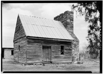
DP recently spent a day with Jobie on-site at the Green Hill Plantation in Campbell County, VA. Also on location was a team of preservationists, scanning technicians from Trimble, and C-Span network television. Green Hill Plantation was established in the 1797. The original owner was very active in the slave trade, making the site rich in history and material culture. Today there are about twenty remaining structures on the plantation, spread out over 198 acres. The team had their work cut out for them - scanning the entire site in just 2 ½ days. While Jobie documented the site with photographs, GPS and a digital survey form, the Trimble team scanned, surveyed and mapped the plantation in its entirety - buildings and landscape - using a Trimble TX8 Laser Scanner and a Trimble R10 GNSS System. They were able to capture multiple images and create a dimensional point cloud. The final product for Jobie is a 3D model of the plantation which can be used in a variety of ways: 360° views of the plantation (interiors & exteriors); measured drawings of the buildings, floor plans, elevations, virtual reality applications, even 3D printing of the buildings - a vast improvement over the traditional 2D images.
As the surveying season came to a close Jobie was wrapping up her endeavors in the mid-Atlantic area and looking to other regions of the U.S. to continue her work. When she has reached her goal the database will be an invaluable archive, safeguarding these pieces of American history long after the dwellings themselves are gone. A 50-minute C-Span presentation on the documentation of Green Hill Plantation can be viewed here.