SKU
spfast

Spectra Geospatial Fast Survey Software

The new FAST Survey™ edition combines advanced functionality, ease-of-use, and sheer capability to make it the first choice in data collection software. FAST Survey is a complete data collection system for Real Time Kinematic (RTK) GNSS and Total Stations with in-field coordinate geometry. It has been designed to optimize the functionality, performance and control of the ProMark and ProFlex GNSS receivers for topography and construction applications. FAST Survey supports as well the widest range of popular and newly released RTK GNSS receivers and conventional/robotic total stations.

Product Details

Easy Data Collection

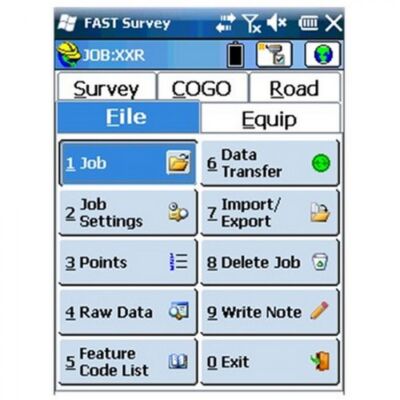
Tab-Based MENU Structure. All commands are visible in each menu, preventing the need for Up-Down Arrow Keying to view options. Collect points in the graphics mode. Points plot as they are shot in the field or entered. There is no need to switch between screens to view your points.

Enhanced Graphics
FAST Survey has a new colorful look. Icons have been standardized to create continuity throughout the product, while modernizing the user experience. The new Hot List lets users jump to the FAST Survey routines that previously had shortcuts without having to memorize key strokes. It also provides shortcut functionality to devices without keyboards.

Settings and Control
FAST Survey manages job and antenna settings, network connections, as well as radio configurations. It supports the complete range of Ashtech GNSS receivers as well as multiple survey instruments. FAST Survey keeps track of every device completely separately. This includes all base stations, rovers and total stations, so that mixing equipment is easy.

Volumes Computation
FAST Survey can compute volumes between two surfaces, one surface and an elevation or simple stockpile volumes. Surfaces can be defined by graphical entities and points or by TIN files.

See More Details

Price Match Guarantee

Shop with Confidence

Not only have we been partners to the survey, engineering and construction industry for decades, but we want to make sure your shopping experience at Duncan-Parnell is worry-free. That’s why we’re offering you our Price Match Guarantee on select products on our website.* If you find a lower price on any geospatial item (identical brand and model#) we sell, we’ll match it, up to 2 weeks after you purchase it.

How does it work?

  • Purchase an eligible item (largely those from our geospatial category of products).
  • Find a lower advertised price another retailer/company with the same brand and model #, and let us know within 14 days of your purchase.
  • Duncan-Parnell will match it. Just call our toll-free geospatial customer service line at 1-833-834-3935

Terms & Exclusions:

  • This offer applies only to advertised online price of identical items (brand and model#) for sales by Duncan-Parnell and other survey and mapping dealers.
  • Price to be matched does Not include discounts from any loyalty or membership programs.
  • Price match does not apply to:
    • Auction site pricing
    • Used, rebuilt or refurbished equipment
  • Only one price match per customer.
FOR HELP OR MORE INFORMATION call us: 833.834.3935