Configuring NEW Collector (Aurora) for ArcGIS with Trimble Mapping Receiver
Configuring NEW Collector (Aurora) for ArcGIS with Trimble Mapping Receiver
- Press power button on receiver to start pairing mode.
- Enable Bluetooth on iOS device. Confirm that iOS pairs with receiver. (R2 receivers will be listed as “R2
Trimble,” while R1 receivers will be shown as “GNSS: ” (ie GNSS: 68033). - Open up NEW Collector.
- Open the Collector Map. The GNSS accuracy will be shown across the top.
- Tap the bar if you wish to see more GNSS Info like number of satellites, PDOP, etc
- Click on your avatar to open up settings.

- Click on Provider (under Location).
- Click Add and choose the Trimble Bluetooth Receiver that you have paired.
- In the next window, enter the Antenna Height.
- Enter the real-time correction source (SBAS if not using an internet or other satellite-based correction). Here we are using NTRIP for the NCVRS network.
- Click Server and enter the url and port. (NC is always rtn.nc.gov and port 2101). Click Connect.
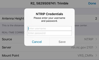
- Choose the mountpoint. When you click Done, you will be prompted for username and password. This comes from the correction source provider. Click Save.
- Click Done on the Provider details.
- Click Profile to return back to settings.
*Note: If you plan to use other real-time correction sources such as NC VRS, be sure to set the Location Profile correctly. See “Setting up Collector for ArcGIS for high-accuracy data collection.”